
Thank you for supporting this site ❤️
Make a donation
Make a donation
Tanah Merah topographic map
Click on the map to display elevation.
Thank you for supporting this site ❤️
Make a donation
Make a donation
About this map
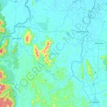
Name: Tanah Merah topographic map, elevation, terrain.
Location: Tanah Merah, Kelantan, Malaysia (5.51233 101.87671 5.93490 102.18175)
Average elevation: 95 m
Minimum elevation: 5 m
Maximum elevation: 1,016 m
Thank you for supporting this site ❤️
Make a donation
Make a donation
Other topographic maps
Click on a map to view its topography, its elevation and its terrain.
Mount Chamah
Gunung Chamah lies in the north-western corner of Kelantan and is the fifth highest mountain in Peninsular Malaysia. It is one of the Peninsula's G7 (mountains above 7,000 ft/2,134m). Gunung in Malay literally means mountains with an elevation of 1,000 m and above. In Peninsular Malaysia, there are several of…
Average elevation: 1,810 m