
Thank you for supporting this site ❤️
Make a donation
Make a donation
Huila topographic map
Click on the map to display elevation.
Thank you for supporting this site ❤️
Make a donation
Make a donation
About this map
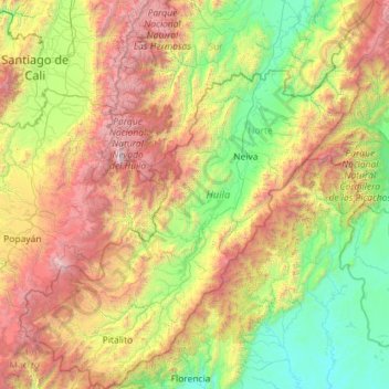
Name: Huila topographic map, elevation, terrain.
Location: Huila, RAP (Especial) Central, Colombia (1.55547 -76.62426 3.84485 -74.41166)
Average elevation: 1,592 m
Minimum elevation: 215 m
Maximum elevation: 5,273 m
Thank you for supporting this site ❤️
Make a donation
Make a donation
Other topographic maps
Click on a map to view its topography, its elevation and its terrain.
Thank you for supporting this site ❤️
Make a donation
Make a donation
Thank you for supporting this site ❤️
Make a donation
Make a donation
Centro
Colombia > Norte de Santander > Villa del Rosario > Villa del Rosario > Centro
Average elevation: 433 m
Thank you for supporting this site ❤️
Make a donation
Make a donation