
Thank you for supporting this site ❤️
Make a donation
Make a donation
Pfaffenthal topographic map
Click on the map to display elevation.
Thank you for supporting this site ❤️
Make a donation
Make a donation
Pfaffenthal
Le Pfaffenthal, ensemble avec la partie appelée Sichenhaff, est parmi les vieux quartiers de Luxembourg-Ville, à savoir Stadtgrund, Clausen et Pfaffenthal, l’un des plus pittoresques de par son histoire, sa topographie, ses monuments et vestiges historiques et archéologiques, sa population, ses coutumes, sa situation…
Thank you for supporting this site ❤️
Make a donation
Make a donation
About this map
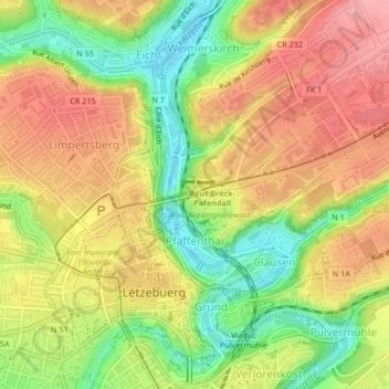
Name: Pfaffenthal topographic map, elevation, terrain.
Location: Pfaffenthal, Luxembourg, Canton Luxembourg, Luxembourg (49.61162 6.13038 49.62448 6.13951)
Average elevation: 301 m
Minimum elevation: 238 m
Maximum elevation: 353 m
Thank you for supporting this site ❤️
Make a donation
Make a donation
Other topographic maps
Click on a map to view its topography, its elevation and its terrain.
Luxembourg Ville: Vieux quartiers & fortifications
Luxembourg > Canton Luxembourg > Luxembourg
Average elevation: 294 m