
Thank you for supporting this site ❤️
Make a donation
Make a donation
Kapit topographic map
Click on the map to display elevation.
Thank you for supporting this site ❤️
Make a donation
Make a donation
About this map
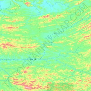
Name: Kapit topographic map, elevation, terrain.
Location: Kapit, Kapit Division, Sarawak, 96800, Malaysia (1.76091 112.65114 2.59035 113.71975)
Average elevation: 194 m
Minimum elevation: 3 m
Maximum elevation: 1,239 m
Thank you for supporting this site ❤️
Make a donation
Make a donation
Other topographic maps
Click on a map to view its topography, its elevation and its terrain.
Thank you for supporting this site ❤️
Make a donation
Make a donation