
Thank you for supporting this site ❤️
Make a donation
Make a donation
La Chorrera topographic map
Click on the map to display elevation.
Thank you for supporting this site ❤️
Make a donation
Make a donation
About this map
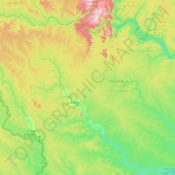
Name: La Chorrera topographic map, elevation, terrain.
Location: La Chorrera, Amazonas, Colombia (-2.18506 -73.84130 -0.38010 -71.97995)
Average elevation: 155 m
Minimum elevation: 83 m
Maximum elevation: 359 m
Thank you for supporting this site ❤️
Make a donation
Make a donation
Other topographic maps
Click on a map to view its topography, its elevation and its terrain.
Leticia
Leticia (Spanish pronunciation: [leˈtisja]) is the southernmost city in the Republic of Colombia, capital of the department of Amazonas, Colombia's southernmost town (4.09° south 69.57° west) and one of the major ports on the Amazon River. It has an elevation of 96 meters (315') above sea level and an…
Average elevation: 71 m