
Bath topographic map
Click on the map to display elevation.
Bath
Bath is in the Avon Valley and is surrounded by limestone hills as it is near the southern edge of the Cotswolds, a designated Area of Outstanding Natural Beauty, and the limestone Mendip Hills rise around 7 miles (11 km) south of the city. The hills that surround and make up the city have a maximum altitude of 781 feet (238 metres) on the Lansdown plateau. Bath has an area of 11 square miles (28 square kilometres).
About this map
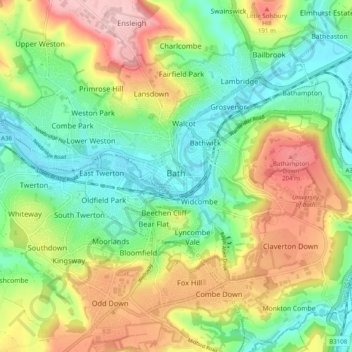
Name: Bath topographic map, elevation, terrain.
Average elevation: 100 m
Minimum elevation: 14 m
Maximum elevation: 235 m