
Thank you for supporting this site ❤️
Make a donation
Make a donation
Chiloé Island topographic map
Click on the map to display elevation.
Thank you for supporting this site ❤️
Make a donation
Make a donation
About this map
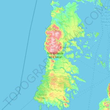
Name: Chiloé Island topographic map, elevation, terrain.
Location: Chiloé Island, Los Lagos Region, Chile (-43.42857 -74.40525 -41.76674 -73.33746)
Average elevation: 44 m
Minimum elevation: -1 m
Maximum elevation: 861 m
Thank you for supporting this site ❤️
Make a donation
Make a donation
Other topographic maps
Click on a map to view its topography, its elevation and its terrain.