
Thank you for supporting this site ❤️
Make a donation
Make a donation
Sawyer County topographic map
Click on the map to display elevation.
Thank you for supporting this site ❤️
Make a donation
Make a donation
About this map
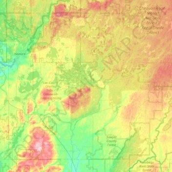
Name: Sawyer County topographic map, elevation, terrain.
Location: Sawyer County, Wisconsin, United States (45.63776 -91.55181 46.15791 -90.67697)
Average elevation: 420 m
Minimum elevation: 340 m
Maximum elevation: 552 m
Thank you for supporting this site ❤️
Make a donation
Make a donation
Other topographic maps
Click on a map to view its topography, its elevation and its terrain.
Thank you for supporting this site ❤️
Make a donation
Make a donation
Thank you for supporting this site ❤️
Make a donation
Make a donation