
Belluno topographic map
Interactive map
Click on the map to display elevation.
About this map
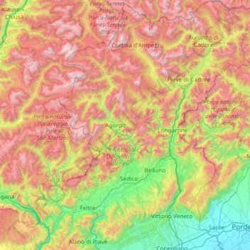
Name: Belluno topographic map, elevation, terrain.
Location: Belluno, Veneto, Italy (45.88044 11.66596 46.68062 12.73226)
Average elevation: 1,308 m
Minimum elevation: 11 m
Maximum elevation: 3,252 m
Other topographic maps
Click on a map to view its topography, its elevation and its terrain.
Ca' Morosini
Italy > Veneto > Padova > Ca' Morosini
Ca' Morosini, Sant'Urbano, Padova, Veneto, 45026, Italy
Average elevation: 7 m
M. Vallesella
Italy > Veneto > Belluno > Falcade
M. Vallesella, Falcade, Belluno, Veneto, Italy
Average elevation: 1,908 m
Cortina d'Ampezzo
Italy > Veneto > Belluno > Cortina d'Ampezzo > Cortina d'Ampezzo
Cortina d'Ampezzo, Belluno, Veneto, 32043, Italy
Average elevation: 1,649 m
Bosco Chiesanuova
Italy > Veneto > Bosco Chiesanuova
Bosco Chiesanuova, VR, Veneto, 37021, Italy
Average elevation: 1,111 m