
Sherman Island topographic map
Interactive map
Click on the map to display elevation.
About this map
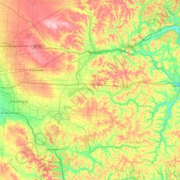
Name: Sherman Island topographic map, elevation, terrain.
Location: Sherman Island, Perry County, Ohio, 43076, USA (39.60368 -82.74460 40.24368 -82.10460)
Average elevation: 294 m
Minimum elevation: 211 m
Maximum elevation: 413 m
Other topographic maps
Click on a map to view its topography, its elevation and its terrain.
Cheviot Hills
USA > Ohio > Cheviot Hills
Cheviot Hills, Clark County, Ohio, 45505, USA
Average elevation: 321 m
Burton Lake
USA > Ohio > Burton Lake
Burton Lake, Burton Township, Geauga County, Ohio, 44021, USA
Average elevation: 348 m
Greenhills
USA > Ohio > Greenhills
Greenhills, Hamilton County, Ohio, 45218, USA
Average elevation: 238 m
Wedge Island
USA > Ohio > Russells Point
Wedge Island, Russells Point, Washington Township, Logan County, Ohio, USA
Average elevation: 303 m