
Make a donation
Foča topographic map
Click on the map to display elevation.
Make a donation
About this map
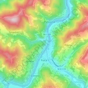
Name: Foča topographic map, elevation, terrain.
Average elevation: 609 m
Minimum elevation: 374 m
Maximum elevation: 992 m
Make a donation
Other topographic maps
Click on a map to view its topography, its elevation and its terrain.
Ravna planina
Bosnia and Herzegovina > Republika Srpska > City of Istočno Sarajevo > Gornje Pale
Average elevation: 1,265 m
Prnjavor
Bosnia and Herzegovina > Republika Srpska > Town of Prnjavor
The municipality is located in the basin of the Ukrina river and is characterized by a mostly lowland hilly terrain configuration with the highest peak of 594m (mountain Ljubić). The Municipality of Prnjavor is shielded on all sides by low mountains such as Ljubić (south) and Motajica (north). The town of…
Average elevation: 180 m
Make a donation
Make a donation
Kanal Dašnica
Bosnia and Herzegovina > Republika Srpska > City of Bijeljina > Bijeljina
Average elevation: 93 m
Make a donation
Jahorina
Bosnia and Herzegovina > Republika Srpska > City of Istočno Sarajevo
Jahorina (Serbian Cyrillic: Јахорина, pronounced [jâxɔrina]) is a mountain in Bosnia and Herzegovina, located at the tripoint of the municipalities of Pale, Trnovo, Republika Srpska and Trnovo, Federation of Bosnia and Herzegovina. Part of the Dinaric Alps, it borders Mount Trebević. Its highest…
Average elevation: 1,131 m
Make a donation
Kozarački kamen
Bosnia and Herzegovina > Republika Srpska > City of Prijedor > MZ Kozarac
Average elevation: 449 m
Make a donation
Velika Manjača
Bosnia and Herzegovina > Republika Srpska > City of Banja Luka
Average elevation: 1,050 m
Tatarevina
Bosnia and Herzegovina > Republika Srpska > Town of Prnjavor > Doline
Average elevation: 172 m
Make a donation
Jahorina
Bosnia and Herzegovina > Republika Srpska > City of Istočno Sarajevo
Jahorina (Serbian Cyrillic: Јахорина, pronounced [jâxɔrina]) is a mountain in Bosnia and Herzegovina, located at the tripoint of the municipalities of Pale, Trnovo, Republika Srpska and Trnovo, Federation of Bosnia and Herzegovina. Part of the Dinaric Alps, it borders Mount Trebević. Its highest…
Average elevation: 1,131 m
Han Pijesak
Bosnia and Herzegovina > Republika Srpska
Han Pijesak is located about 70km northeast from Sarajevo, on the slopes of mountain Romanija, at an altitude of 1,100m.
Average elevation: 1,092 m
Han Pijesak
Bosnia and Herzegovina > Republika Srpska
Han Pijesak is located about 70km northeast from Sarajevo, on the slopes of mountain Romanija, at an altitude of 1,100m.
Average elevation: 1,092 m
Make a donation
Blizanci
Bosnia and Herzegovina > Republika Srpska > City of Istočno Sarajevo > MZ Trebević
Average elevation: 1,061 m
Make a donation
Make a donation
Jahorina
Bosnia and Herzegovina > Republika Srpska > City of Istočno Sarajevo
Jahorina (Serbian Cyrillic: Јахорина, pronounced [jâxɔrina]) is a mountain in Bosnia and Herzegovina, located at the tripoint of the municipalities of Pale, Trnovo, Republika Srpska and Trnovo, Federation of Bosnia and Herzegovina. Part of the Dinaric Alps, it borders Mount Trebević. Its highest…
Average elevation: 1,131 m
Make a donation
Šipovo
Bosnia and Herzegovina > Republika Srpska
In the geomorphologic sense, Šipovo is a mountain region whose average height is 800 metres above sea level. In the global climatic sense, Šipovo lies in temperately continental zone, with certain differences the reason for which being variations in height above sea level, as well as topographic and…
Average elevation: 612 m
Teslić
Bosnia and Herzegovina > Republika Srpska
The municipality of Teslić is located in the northern part of Central Bosnia, encompassing the southern part of the western half of the Republic of Srpska. With a territory of 846 km², it ranks among the largest municipalities in the Republic of Srpska. It borders the municipalities of Doboj, Tešanj,…
Average elevation: 278 m
Make a donation