
Thank you for supporting this site ❤️
Make a donation
Make a donation
Kouba topographic map
Click on the map to display elevation.
Thank you for supporting this site ❤️
Make a donation
Make a donation
About this map
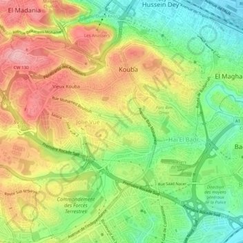
Name: Kouba topographic map, elevation, terrain.
Location: Kouba, Hussein Dey District, Algiers, Algeria (36.70434 3.05295 36.74357 3.10157)
Average elevation: 71 m
Minimum elevation: 0 m
Maximum elevation: 151 m
Thank you for supporting this site ❤️
Make a donation
Make a donation
Other topographic maps
Click on a map to view its topography, its elevation and its terrain.
El Magharia
Algeria > Algiers > Hussein Dey District > El Magharia > El Magharia
Average elevation: 30 m