
Thank you for supporting this site ❤️
Make a donation
Make a donation
Kodaikanal topographic map
Click on the map to display elevation.
Thank you for supporting this site ❤️
Make a donation
Make a donation
About this map
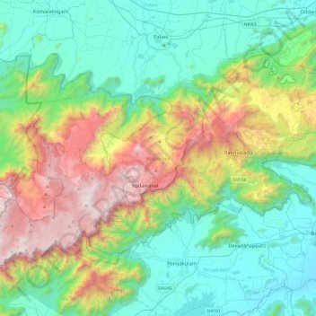
Name: Kodaikanal topographic map, elevation, terrain.
Location: Kodaikanal, Dindigul District, Tamil Nadu, India (10.11691 77.26649 10.43050 77.73587)
Average elevation: 869 m
Minimum elevation: 218 m
Maximum elevation: 2,502 m
Thank you for supporting this site ❤️
Make a donation
Make a donation
Other topographic maps
Click on a map to view its topography, its elevation and its terrain.
Chennai
Chennai is located on the southeastern coast of India in the northeastern part of Tamil Nadu on a flat coastal plain known as the Eastern Coastal Plains with an average elevation of 6.7 m (22 ft) and highest point at 60 m (200 ft). Chennai's soil is mostly clay, shale and sandstone. Clay underlies most of the…
Average elevation: 7 m