
Locarno topographic map
Interactive map
Click on the map to display elevation.
About this map
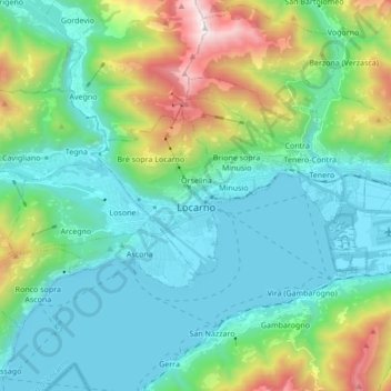
Name: Locarno topographic map, elevation, terrain.
Average elevation: 608 m
Minimum elevation: 184 m
Maximum elevation: 2,024 m
The municipality is the capital of its district. Locarno is located on the left shore of Lake Maggiore. The city is made up of the old town (historic settlement centre), the new town (Nuovo quartiere) toward the lake and the land district (quartiere Campagna) toward Solduno. The area of the municipality extends from the lake (elevation 209 m (686 ft)) to the mountains above the city (Monti della SS Trinità, Bre, Cardada and Cimetta, the highest point at 1,474 m (4,836 ft)). It includes a large part of the Magadino valley along with the right side of the Ticino river, and stretches from the Bolle di Magadino to Monda Contone.
Other topographic maps
Click on a map to view its topography, its elevation and its terrain.
Brè sopra Locarno
Switzerland > Ticino > Distretto di Locarno > Locarno
Brè sopra Locarno, Locarno, Circolo di Locarno, Distretto di Locarno, Ticino, 6605, Switzerland
Average elevation: 659 m