
Thank you for supporting this site ❤️
Make a donation
Make a donation
Vaihingen an der Enz topographic map
Click on the map to display elevation.
Thank you for supporting this site ❤️
Make a donation
Make a donation
Vaihingen an der Enz
Vaihingen lies at an altitude of 200 to 450 metres at the end of the Strohgäus, on the western edge of the Neckarbecken in a valley widening of the Enz. The town centre lies on the east side of the river and is overlooked by the castle Kaltenstein.
Thank you for supporting this site ❤️
Make a donation
Make a donation
About this map
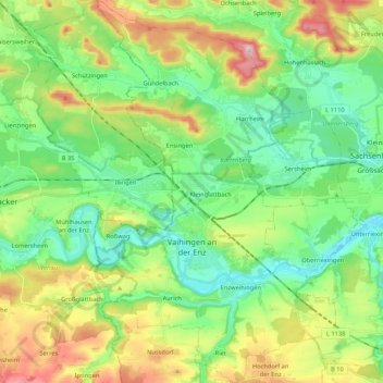
Name: Vaihingen an der Enz topographic map, elevation, terrain.
Average elevation: 283 m
Minimum elevation: 189 m
Maximum elevation: 475 m
Thank you for supporting this site ❤️
Make a donation
Make a donation