Geolocate

City of Edinburgh topographic map

Click on the map to display elevation.

City of Edinburgh

Edinburgh has been popularly called the Athens of the North since the early 19th century. References to Athens, such as Athens of Britain and Modern Athens, had been made as early as the 1760s. The similarities were seen to be topographical but also intellectual. Edinburgh's Castle Rock reminded returning grand tourists of the Athenian Acropolis, as did aspects of the neoclassical architecture and layout of New Town. Both cities had flatter, fertile agricultural land sloping down to a port several miles away (respectively, Leith and Piraeus). Intellectually, the Scottish Enlightenment, with its humanist and rationalist outlook, was influenced by Ancient Greek philosophy. In 1822, artist Hugh William Williams organized an exhibition that showed his paintings of Athens alongside views of Edinburgh, and the idea of a direct parallel between both cities quickly caught the popular imagination. When plans were drawn up in the early 19th century to architecturally develop Calton Hill, the design of the National Monument directly copied Athens' Parthenon. Tom Stoppard's character Archie of Jumpers said, perhaps playing on Reykjavík meaning "smoky bay", that the "Reykjavík of the South" would be more appropriate.

Wikipedia (CC-BY-SA 3.0)

About this map

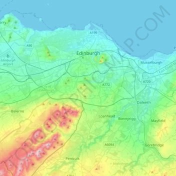
Name: City of Edinburgh topographic map, elevation, terrain.

Location: City of Edinburgh, Scotland, United Kingdom (55.81879 -3.44953 56.00408 -3.07495)

Average elevation: 118 m

Minimum elevation: 0 m

Maximum elevation: 578 m

Other topographic maps

Click on a map to view its topography, its elevation and its terrain.

Edinburgh

United Kingdom > Scotland > Edinburgh

Some have called Edinburgh the Athens of the North for a variety of reasons. The earliest comparison between the two cities showed that they had a similar topography, with the Castle Rock of Edinburgh performing a similar role to the Athenian Acropolis. Both of them had flatter, fertile agricultural land…

Average elevation: 104 m

Glasgow

United Kingdom > Scotland > Glasgow City

Glasgow itself was reputed to have been founded by the Christian missionary Saint Mungo in the 6th century. He established a church on the Molendinar Burn, where the present Glasgow Cathedral stands, and in the following years Glasgow became a religious centre. Glasgow grew over the following centuries. The…

Average elevation: 128 m

Langdale

United Kingdom > Scotland > Highland

Average elevation: 115 m

Oban

United Kingdom > Scotland > Argyll and Bute

Average elevation: 52 m

Coulport

United Kingdom > Scotland > Argyll and Bute

Average elevation: 61 m

Scottish Highlands

United Kingdom > Scotland > Highland

The entire region was covered by ice sheets during the Pleistocene ice ages, save perhaps for a few nunataks. The complex geomorphology includes incised valleys and lochs carved by the action of mountain streams and ice, and a topography of irregularly distributed mountains whose summits have similar heights…

Average elevation: 907 m

Kinlochewe

United Kingdom > Scotland > Highland

Average elevation: 153 m

Cowie

United Kingdom > Scotland > Stirling

Average elevation: 30 m

Muirburn

United Kingdom > Scotland > Scottish Borders

Average elevation: 301 m

Grey Mare's Tail

United Kingdom > Scotland

Average elevation: 466 m

Dundee

United Kingdom > Scotland > Dundee City

Dundee sits on the north bank of the Firth of Tay on the eastern, North Sea Coast of Scotland. The city lies 36.1 miles (58 km) NNE of Edinburgh and 360.6 miles (580 km) NNW of London. The built-up area occupies a roughly rectangular shape 8.3 miles (13 km) long by 2.5 miles (4 km) wide, aligned in an east to…

Average elevation: 82 m

Dunbar

United Kingdom > Scotland > East Lothian

Average elevation: 24 m

Pitlochry

United Kingdom > Scotland > Perth and Kinross

Average elevation: 276 m

Glencoe

United Kingdom > Scotland > Highland

Average elevation: 114 m

Waterloo

United Kingdom > Scotland > Perth and Kinross

Average elevation: 115 m

Kenknock

United Kingdom > Scotland > Stirling

Average elevation: 434 m

Kilwinning

United Kingdom > Scotland > North Ayrshire

Average elevation: 36 m

Nethy Bridge

United Kingdom > Scotland > Highland

Average elevation: 230 m

Melness

United Kingdom > Scotland > Highland

Average elevation: 39 m

Clachan

United Kingdom > Scotland > Argyll and Bute

Average elevation: 75 m

Harelaw

United Kingdom > Scotland > Scottish Borders > Chirnside

Average elevation: 90 m

Livingston

United Kingdom > Scotland > West Lothian

Average elevation: 158 m

Ben Nevis

United Kingdom > Scotland > Highland

Ben Nevis has a highland (alpine) maritime (oceanic) polar climate (ET climate in the Köppen classification). Ben Nevis's elevation, maritime location and topography frequently lead to cool and cloudy weather conditions, which can pose a danger to ill-equipped walkers. According to the observations carried…

Average elevation: 912 m

Aberdeen

United Kingdom > Scotland > Aberdeen

Two weather stations collect climate data for the area, Aberdeen/Dyce Airport, and Craibstone. Both are about 4 1⁄2 miles (7 km) to the north west of the city centre, and given that they are in close proximity to each other, exhibit very similar climatic regimes. Dyce tends to have marginally warmer daytime…

Average elevation: 52 m

Rothes

United Kingdom > Scotland > Moray

Average elevation: 139 m

Falkirk

United Kingdom > Scotland > Falkirk

Falkirk is located in an area of undulating topography between the Slamannan Plateau and the upper reaches of the Firth of Forth. The area to the north of Falkirk is part of the floodplain of the River Carron. Two tributaries of the River Carron - the East Burn and the West Burn flow through the town and form…

Average elevation: 69 m

Dunkeld

United Kingdom > Scotland > Perth and Kinross

Average elevation: 190 m

Barrhead

United Kingdom > Scotland > East Renfrewshire

Average elevation: 93 m

Iona

United Kingdom > Scotland

Average elevation: 9 m

Scourie

United Kingdom > Scotland > Highland

Average elevation: 51 m

Torridon

United Kingdom > Scotland > Highland

Average elevation: 236 m

Drum

United Kingdom > Scotland > Perth and Kinross

Average elevation: 167 m

Stirlingshire

United Kingdom > Scotland

Average elevation: 222 m

Glen Dochart

United Kingdom > Scotland

Average elevation: 469 m

Daviot

United Kingdom > Scotland > Highland

Average elevation: 230 m

Inveresk

United Kingdom > Scotland > East Lothian

Average elevation: 22 m

Loch Lochy

United Kingdom > Scotland > Highland

Average elevation: 363 m

Inverness-shire

United Kingdom > Scotland

Average elevation: 333 m

Urquhart Castle

United Kingdom > Scotland > Highland > Strone

Average elevation: 49 m

Larach Beag

United Kingdom > Scotland > Highland

Average elevation: 100 m

Ardfin

United Kingdom > Scotland > Argyll and Bute

Average elevation: 57 m

Snap

United Kingdom > Scotland

Average elevation: 3 m

Glasgow

United Kingdom > Scotland > Glasgow City

Glasgow itself was reputed to have been founded by the Christian missionary Saint Mungo in the 6th century. He established a church on the Molendinar Burn, where the present Glasgow Cathedral stands, and in the following years Glasgow became a religious centre. Glasgow grew over the following centuries as part…

Average elevation: 128 m

Killearn

United Kingdom > Scotland > Stirling

Average elevation: 82 m

Argyll and Bute

United Kingdom > Scotland

Average elevation: 683 m

The Campsie Fells

United Kingdom > Scotland

Average elevation: 431 m

Western Isles

United Kingdom > Scotland

Average elevation: 23 m

Ayrshire

United Kingdom > Scotland

Average elevation: 141 m

Inchmickery

United Kingdom > Scotland

Average elevation: 0 m

Ailsa Craig

United Kingdom > Scotland

In a small glen above Ailsa Castle, a small freshwater body known as the Garry Loch is located at an altitude of 247 m (810 ft), with a depth of at least 17 feet.

Average elevation: 14 m

Banffshire

United Kingdom > Scotland

Average elevation: 191 m

Mull of Kintyre

United Kingdom > Scotland

Ailsa Craig and the County Antrim coast of Ulster and Rathlin Island are all clearly visible from the Mull. On clearer days it is also possible to make out Malin Head in Inishowen in County Donegal in the west of Ulster, and the Ayrshire coast on the other side of Ailsa Craig. Other islands in the Firth of…

Average elevation: 84 m

Auchencorth Moss

United Kingdom > Scotland

Average elevation: 281 m

Denton Burn

United Kingdom > Scotland

Average elevation: 154 m

Taynish Island

United Kingdom > Scotland

Average elevation: 11 m

Devil's Beef Tub

United Kingdom > Scotland

Average elevation: 376 m

Meall Aundrary

United Kingdom > Scotland

Average elevation: 194 m

River Kerry

United Kingdom > Scotland

Average elevation: 118 m

Burian Hole

United Kingdom > Scotland

Average elevation: 36 m

Papa

United Kingdom > Scotland

Average elevation: 2 m

Sgùrr na Stri

United Kingdom > Scotland

Average elevation: 92 m

Braid Hill

United Kingdom > Scotland

Average elevation: 353 m

Loch Urigill

United Kingdom > Scotland

Average elevation: 172 m

Buachaille Etive Mor

United Kingdom > Scotland

Average elevation: 585 m

Highland

United Kingdom > Scotland

Average elevation: 402 m

Glen Croe

United Kingdom > Scotland

Average elevation: 355 m

Barrnacarry Bay

United Kingdom > Scotland

Average elevation: 32 m

Garve

United Kingdom > Scotland > Highland

Average elevation: 169 m

Ben Ledi

United Kingdom > Scotland > Stirling

Average elevation: 544 m

Doune

United Kingdom > Scotland > Stirling

Average elevation: 56 m

Hoxa

United Kingdom > Scotland > Orkney Islands

Average elevation: 6 m

Lanarkshire

United Kingdom > Scotland

Average elevation: 183 m

Rubha nam Bùthan

United Kingdom > Scotland

Average elevation: 15 m

Maol Chinn-dearg

United Kingdom > Scotland > Highland

Average elevation: 587 m

The Minch

United Kingdom > Scotland

Average elevation: 63 m

Firth of Clyde

United Kingdom > Scotland

Average elevation: 0 m

St Magnus' Bay

United Kingdom > Scotland

Average elevation: 6 m

Kilmarnock

United Kingdom > Scotland > East Ayrshire

Average elevation: 56 m

Stromness

United Kingdom > Scotland > Orkney Islands

Average elevation: 21 m

Ayr

United Kingdom > Scotland > South Ayrshire

Average elevation: 18 m

Newtonmore

United Kingdom > Scotland > Highland

Newtonmore is located within the Cairngorms National Park, approximately 3 miles (5 km) southwest of Kingussie and 15 miles (24 km) southwest of Aviemore. It is on the northeastern bank of the River Spey, between the River Calder and the Allt Lairaidh, at an altitude of approximately 250 metres (820 ft).

Average elevation: 283 m

Carluke

United Kingdom > Scotland > South Lanarkshire

Average elevation: 191 m

Elgin

United Kingdom > Scotland > Moray

Elgin is first documented in the Cartulary of Moray in 1190 AD. It was created a royal burgh in the 12th century by King David I of Scotland, and by that time had a castle on top of the present-day Lady Hill to the west of the town. The origin of the name Elgin is likely to be Celtic. It may derive from…

Average elevation: 26 m

Blantyre

United Kingdom > Scotland > South Lanarkshire

Average elevation: 84 m

Fort William

United Kingdom > Scotland > Highland

Fort William has an oceanic climate (Cfb) with moderate, but generally cool, temperatures and abundant precipitation. In the towns immediate vicinity, there are significant variations in elevation, which leads to some uninhabited areas near the town having a subpolar oceanic climate (Cfc), or, at the absolute…

Average elevation: 122 m