
Thank you for supporting this site ❤️
Make a donation
Make a donation
Ciudad Satélite topographic map
Click on the map to display elevation.
Thank you for supporting this site ❤️
Make a donation
Make a donation
About this map
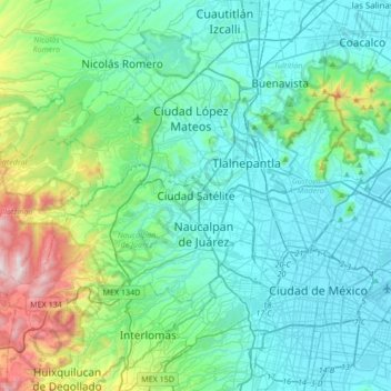
Name: Ciudad Satélite topographic map, elevation, terrain.
Average elevation: 2,451 m
Minimum elevation: 2,223 m
Maximum elevation: 3,509 m
Thank you for supporting this site ❤️
Make a donation
Make a donation
Other topographic maps
Click on a map to view its topography, its elevation and its terrain.
Naucalpan de Juárez
The highest peaks are the Organo and La Malinche mountains at 3,650 metres (11,980 feet) above sea level. Other notable elevations include la Cantera, El Cedral, San Joselito, La Plantación and Peña del Rayo. The main rivers through the area include the Totolina, San Lorenzo and Los Remedios. Water supply…
Average elevation: 2,366 m