
Kraków County topographic map
Interactive map
Click on the map to display elevation.
About this map
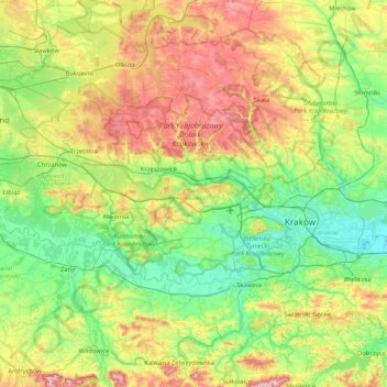
Name: Kraków County topographic map, elevation, terrain.
Location: Kraków County, Lesser Poland Voivodeship, Poland (49.88519 19.52039 50.31465 20.35376)
Average elevation: 307 m
Minimum elevation: 191 m
Maximum elevation: 559 m
Other topographic maps
Click on a map to view its topography, its elevation and its terrain.
Nowy Targ County
Poland > Lesser Poland Voivodeship
Nowy Targ County, Lesser Poland Voivodeship, Poland
Average elevation: 757 m
Rolica
Poland > Lesser Poland Voivodeship > Rolica
Rolica, gmina Gdów, powiat wielicki, Lesser Poland Voivodeship, 32-013, Poland
Average elevation: 256 m
Krakow
Poland > Lesser Poland Voivodeship > Krakow
Krakow, Lesser Poland Voivodeship, Poland
Average elevation: 263 m
Krakow
Poland > Lesser Poland Voivodeship
Krakow, Lesser Poland Voivodeship, Poland
Average elevation: 258 m
Nowy Targ
Poland > Lesser Poland Voivodeship > Nowy Targ
Nowy Targ, powiat nowotarski, Lesser Poland Voivodeship, Poland
Average elevation: 679 m