
Thank you for supporting this site ❤️
Make a donation
Make a donation
East Lindsey topographic map
Click on the map to display elevation.
Thank you for supporting this site ❤️
Make a donation
Make a donation
About this map
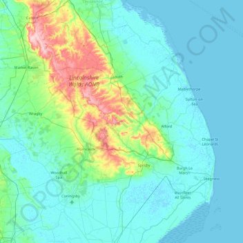
Name: East Lindsey topographic map, elevation, terrain.
Location: East Lindsey, Lincolnshire, England, United Kingdom (53.00109 -0.31748 53.53488 0.35797)
Average elevation: 24 m
Minimum elevation: -1 m
Maximum elevation: 169 m
Thank you for supporting this site ❤️
Make a donation
Make a donation
Other topographic maps
Click on a map to view its topography, its elevation and its terrain.