
Thank you for supporting this site ❤️
Make a donation
Make a donation
Loreto Aprutino topographic map
Click on the map to display elevation.
Thank you for supporting this site ❤️
Make a donation
Make a donation
About this map
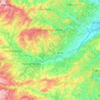
Name: Loreto Aprutino topographic map, elevation, terrain.
Location: Loreto Aprutino, Pescara, 65014, Italy (42.36804 13.90962 42.46285 14.03517)
Average elevation: 226 m
Minimum elevation: 75 m
Maximum elevation: 463 m
Thank you for supporting this site ❤️
Make a donation
Make a donation
Other topographic maps
Click on a map to view its topography, its elevation and its terrain.