
Make a donation
Pontebba / Ponteibe / Pontafel / Tablija topographic map
Click on the map to display elevation.
Make a donation
About this map
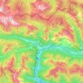
Name: Pontebba / Ponteibe / Pontafel / Tablija topographic map, elevation, terrain.
Average elevation: 1,289 m
Minimum elevation: 436 m
Maximum elevation: 2,273 m
Make a donation
Other topographic maps
Click on a map to view its topography, its elevation and its terrain.
Albana / Ibána / Albane
Italy > Friuli – Venezia Giulia > Udine / Udin / Videm > Prepotto / Prapotno / Prepot
Average elevation: 175 m
Scale / Skale
Italy > Friuli – Venezia Giulia > Udine / Udin / Videm > Drenchia
Average elevation: 610 m
Montemaggiore / Brezje
Italy > Friuli – Venezia Giulia > Udine / Udin / Videm > Taipana
Average elevation: 817 m
Make a donation
Monte Tamai
Italy > Friuli – Venezia Giulia > Udine / Udin / Videm > Ovaro / Davâr
Average elevation: 1,588 m
Monte Lubia / Ljubija
Italy > Friuli – Venezia Giulia > Udine / Udin / Videm > Pulfero
Average elevation: 795 m
Make a donation
Sandrine
Italy > Friuli – Venezia Giulia > Udine / Udin / Videm > Artegna / Dartigne > Borc dal Steli
Average elevation: 263 m