
Georgetown County topographic map
Interactive map
Click on the map to display elevation.
About this map
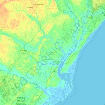
Name: Georgetown County topographic map, elevation, terrain.
Location: Georgetown County, South Carolina, United States of America (33.09464 -79.68111 33.78017 -78.98482)
Average elevation: 6 m
Minimum elevation: -4 m
Maximum elevation: 30 m
Other topographic maps
Click on a map to view its topography, its elevation and its terrain.
Newberry County
United States of America > South Carolina
Newberry County, South Carolina, United States of America
Average elevation: 136 m
Travelers Rest
United States of America > South Carolina > Travelers Rest
Travelers Rest, Greenville County, South Carolina, United States of America
Average elevation: 338 m
Charleston County
United States of America > South Carolina
Charleston County, South Carolina, United States of America
Average elevation: 5 m