
Thank you for supporting this site ❤️
Make a donation
Make a donation
Soatá topographic map
Click on the map to display elevation.
Thank you for supporting this site ❤️
Make a donation
Make a donation
About this map
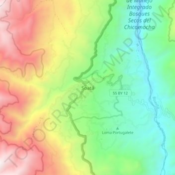
Name: Soatá topographic map, elevation, terrain.
Location: Soatá, Norte, Boyacá, RAP (Especial) Central, 151001, Colombia (6.29519 -72.72036 6.37519 -72.64036)
Average elevation: 2,071 m
Minimum elevation: 1,282 m
Maximum elevation: 3,293 m
Thank you for supporting this site ❤️
Make a donation
Make a donation