
Surrey topographic map
Interactive map
Click on the map to display elevation.
About this map
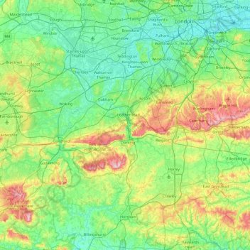
Name: Surrey topographic map, elevation, terrain.
Average elevation: 69 m
Minimum elevation: -1 m
Maximum elevation: 289 m
The highest elevation in Surrey is Leith Hill near Dorking. It is 294 m (965 ft) above sea level and is the second highest point in southeastern England after Walbury Hill in West Berkshire which is 297 m (974 ft) .
Other topographic maps
Click on a map to view its topography, its elevation and its terrain.
Royal Borough of Kensington and Chelsea
United Kingdom > England > London
Royal Borough of Kensington and Chelsea, London, Greater London, England, United Kingdom
Average elevation: 18 m
London Borough of Newham
United Kingdom > England > London
London Borough of Newham, London, Greater London, England, United Kingdom
Average elevation: 8 m
Greenwich Park
United Kingdom > England > London
Greenwich Park, East Greenwich, Royal Borough of Greenwich, London, Greater London, England, United Kingdom
Average elevation: 22 m
Camden Town
United Kingdom > England > London > Camden Town
Camden Town, London, Greater London, England, NW1 9PJ, United Kingdom
Average elevation: 44 m
London
United Kingdom > England > London
London Borough of Sutton, London, Greater London, England, United Kingdom
Average elevation: 71 m