
Charbonnières-les-Vieilles topographic map
Interactive map
Click on the map to display elevation.
About this map
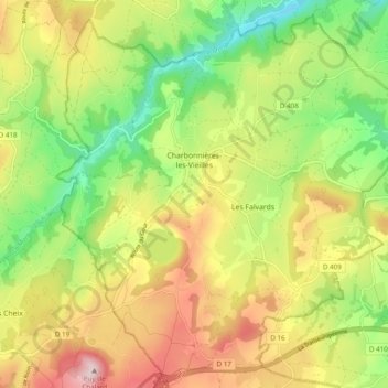
Name: Charbonnières-les-Vieilles topographic map, elevation, terrain.
Average elevation: 627 m
Minimum elevation: 460 m
Maximum elevation: 828 m
Other topographic maps
Click on a map to view its topography, its elevation and its terrain.
Surat
France > Auvergne-Rhône-Alpes > Puy-de-Dôme
Surat, Riom, Puy-de-Dôme, Auvergne-Rhône-Alpes, Metropolitan France, 63720, France
Average elevation: 310 m