
Thank you for supporting this site ❤️
Make a donation
Make a donation
Everett topographic map
Click on the map to display elevation.
Thank you for supporting this site ❤️
Make a donation
Make a donation
About this map
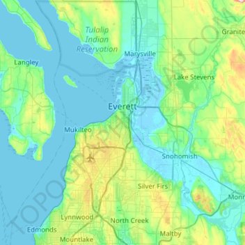
Name: Everett topographic map, elevation, terrain.
Location: Everett, Snohomish County, Washington, United States (47.87818 -122.29397 48.03603 -121.79398)
Average elevation: 66 m
Minimum elevation: -4 m
Maximum elevation: 420 m
Thank you for supporting this site ❤️
Make a donation
Make a donation