
Make a donation
Bogota Capital District - Municipality topographic map
Click on the map to display elevation.
Make a donation
Bogota Capital District - Municipality
The city is located in the center of Colombia, on a high plateau known as the Bogotá savanna, part of the Altiplano Cundiboyacense located in the Eastern Cordillera of the Andes. Its altitude averages 2,640 meters (8,660 ft) above sea level. Subdivided into 20 localities, Bogotá has an area of 1,587 square kilometers (613 square miles) and a cool climate that is constant through the year.
Make a donation
About this map
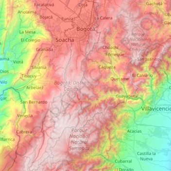
Name: Bogota Capital District - Municipality topographic map, elevation, terrain.
Average elevation: 2,183 m
Minimum elevation: 308 m
Maximum elevation: 4,222 m
Make a donation
Other topographic maps
Click on a map to view its topography, its elevation and its terrain.
Make a donation
Make a donation
Centro
Colombia > Norte de Santander > Villa del Rosario > Villa del Rosario > Centro
Average elevation: 433 m
Make a donation