
Make a donation
Portsmouth topographic map
Click on the map to display elevation.
Make a donation
Portsmouth
Portsmouth is 73.5 miles (118.3 km) by road from central London, 49.5 miles (79.7 km) west of Brighton, and 22.3 miles (35.9 km) east of Southampton. It is located primarily on Portsea Island and is the United Kingdom's only island city, although the city has expanded to the mainland. Gosport is a town and borough to the west. Portsea Island is separated from the mainland by Portsbridge Creek, which is crossed by three road bridges (the M275 motorway, the A3 road, and the A2030 road), a railway bridge, and two footbridges. Portsea Island, part of the Hampshire Basin, is low-lying; most of the island is less than 3 metres (9.8 ft) above sea level. The island's highest natural elevation is the Kingston Cross road junction, at 21 feet (6.4 m) above ordinary spring tide.
Make a donation
About this map
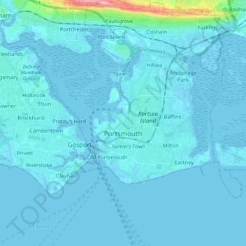
Name: Portsmouth topographic map, elevation, terrain.
Location: Portsmouth, England, United Kingdom (50.74985 -1.17497 50.85931 -1.01849)
Average elevation: 7 m
Minimum elevation: -5 m
Maximum elevation: 129 m
Make a donation
Other topographic maps
Click on a map to view its topography, its elevation and its terrain.
Cambridge
United Kingdom > England > Cambridge
The city, like most of the UK, has a maritime climate highly influenced by the Gulf Stream. Located in the driest region of Britain, Cambridge's rainfall averages around 570 mm (22.44 in) per year, around half the national average, with some years occasionally falling into the semi-arid (under 500 mm (19.69…
Average elevation: 18 m
Make a donation
Crowborough
United Kingdom > England > Wealden > Crowborough
In the late 19th century Crowborough was promoted as a health resort based on its high elevation, the rolling hills and surrounding forest. Estate Agents even called it "Scotland in Sussex". The town's golf course opened in 1895, followed by a fire station and hospital in 1900.
Average elevation: 125 m
Gateshead
United Kingdom > England > Tyne and Wear > Gateshead
One of the most distinguishing features of Gateshead is its topography. The land rises 230 feet (70 m) from Gateshead Quays to the town centre and continues rising to a height of 525 feet (160 m) at Queen Elizabeth Hospital in Sheriff Hill. This is in contrast to the flat and low lying Team Valley located on…
Average elevation: 62 m
Portsmouth
United Kingdom > England > Hampshire > Portsmouth
By road, Portsmouth lies 73.5 miles (118.3 km) from Central London, 49.5 miles (79.7 km) west of Brighton, and 22.3 miles (35.9 km) east of Southampton. Portsmouth is situated primarily on Portsea Island and is the United Kingdom's only island city, although parts of it have expanded onto the mainland. Gosport…
Average elevation: 28 m
Make a donation
Harrow
United Kingdom > England > London Borough of Harrow > Harrow
The town centre is about 220 feet (67 m) above sea level, almost 200 feet (61 m) below the top of Harrow Hill, which is an outlying knoll. The hill is half a mile south of the town centre, and the settlement is rich with historic architecture and has a village atmosphere. The steep climb towards the hill is…
Average elevation: 57 m
Make a donation
Pennines
United Kingdom > England > Westmorland and Furness
The Pennine climate is generally temperate like that of the rest of England, but the hills have more precipitation, stronger winds and colder weather than the surrounding areas. Higher elevations have a tundra climate. More snow falls on the Pennines than on surrounding lowland areas due to the elevation and…
Average elevation: 761 m
Make a donation
Salisbury
United Kingdom > England > Salisbury
Bishop of Salisbury Hubert Walter was instrumental in the negotiations with Saladin during the Third Crusade, but he spent little time in his diocese prior to his elevation to archbishop of Canterbury. The brothers Herbert and Richard Poore succeeded him and began planning the relocation of the cathedral into…
Average elevation: 96 m
Make a donation
Make a donation
Make a donation
Make a donation
Great Park
United Kingdom > England > Oxfordshire > West Oxfordshire > Long Hanborough
Average elevation: 94 m
Make a donation
Make a donation
Lickey Hills Country Park
United Kingdom > England > Worcestershire > Bromsgrove > Cofton Hackett CP
Average elevation: 209 m
Make a donation
Make a donation
Burton upon Trent
United Kingdom > England > Staffordshire > East Staffordshire
Burton is about 109 miles (175 km) north west of London, about 30 miles north east of Birmingham, the UK's second largest city and about 23 miles east of the county town Stafford. It is at the easternmost border of the county of Staffordshire with Derbyshire, its suburbs and the course of the River Trent…
Average elevation: 69 m
Make a donation
Plymouth
United Kingdom > England > Devon > Plymouth
The River Plym, which flows off Dartmoor to the north-east, forms a smaller estuary to the east of the city called Cattewater. Plymouth Sound is protected from the sea by the Plymouth Breakwater, in use since 1814. In the Sound is Drake's Island which is seen from Plymouth Hoe, a flat public area on top of…
Average elevation: 81 m
Make a donation
Leeds
Lying in the eastern foothills of the Pennines, there is a significant variation in elevation within the city's built-up area. The district ranges from 1,115 feet (340 m) in the far west on the slopes of Ilkley Moor to about 33 feet (10 m) where the rivers Aire and Wharfe cross the eastern boundary. Land rises…
Average elevation: 94 m
Cambridge
United Kingdom > England > Cambridgeshire
The city, like most of the UK, has a maritime climate highly influenced by the Gulf Stream. Located in the driest region of Britain, Cambridge's rainfall averages around 570 mm (22.44 in) per year, around half the national average, The driest recent year was in 2011 with 380.4 mm (14.98 in) of rain at the…
Average elevation: 33 m
Littleborough
In the late 18th century, the low-altitude Summit Gap between Littleborough and Walsden was approved as the best route over the Pennines for the Rochdale Canal and the Manchester to Leeds railway; Hollingworth Lake was built at Littleborough's south side as a feeder reservoir to regulate the waters of the…
Average elevation: 266 m
Swindon
United Kingdom > England > Swindon
Swindon has an oceanic climate (Cfb in the Köppen climate classification), like the vast majority of the British Isles, with cool winters and warm summers. The nearest official weather station is RAF Lyneham, about 10 miles (16 km) west southwest of Swindon town centre. The weather station's elevation is 145…
Average elevation: 108 m
Make a donation
Make a donation
Scarborough
United Kingdom > England > North Yorkshire
The climate is temperate with mild summers and cool, windy, winters. The hottest months of the year are July and August, with temperatures reaching an average high of 17 °C and falling to 11 °C at night. The average daytime temperatures in January are 4 °C, falling to 1 °C at night. The station's elevation…
Average elevation: 39 m
Make a donation
Make a donation
Make a donation
Glastonbury Tor
United Kingdom > England > Somerset > Glastonbury
The Tor is in the middle of the Summerland Meadows, part of the Somerset Levels, rising to an elevation of 518 feet (158 m). The plain is reclaimed fen above which the Tor is clearly visible for miles around. It has been described as an island, but actually sits at the western end of a peninsula washed on…
Average elevation: 33 m
Make a donation
North Walsham and Dilham Canal
United Kingdom > England > Norfolk > North Norfolk > Honing
Average elevation: 21 m
Make a donation
Make a donation
Damflask Reservoir
United Kingdom > England > South Yorkshire > Sheffield > Low Bradfield
Average elevation: 234 m
Breedon on the Hill
United Kingdom > England > Leicestershire > North West Leicestershire
Average elevation: 84 m
Make a donation
Make a donation
Sydenham
United Kingdom > England > Greater London
In the area where West Hill (later renamed Westwood Hill) and Crystal Palace Park Road raise in elevation and eventually meet, many fine villas were built in the latter half of the nineteenth century. Designed in revival architectural styles, fashionable at the time, most of the properties were three or four…
Average elevation: 45 m
Make a donation