
Thank you for supporting this site ❤️
Make a donation
Make a donation
Pleiku topographic map
Click on the map to display elevation.
Thank you for supporting this site ❤️
Make a donation
Make a donation
Pleiku
Pleiku is located at an average altitude of 700m - 800m; Ham Rong junction, or the junction of National Highway 14 and National Highway 19 south of Pleiku, has an altitude of 785m.
Thank you for supporting this site ❤️
Make a donation
Make a donation
About this map
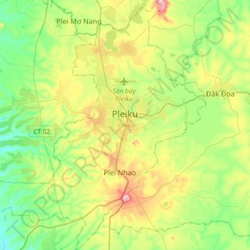
Name: Pleiku topographic map, elevation, terrain.
Location: Pleiku, Gia Lai Province, Vietnam (13.83352 107.83873 14.08711 108.09938)
Average elevation: 724 m
Minimum elevation: 579 m
Maximum elevation: 1,017 m
Thank you for supporting this site ❤️
Make a donation
Make a donation