
Make a donation
Westport topographic map
Click on the map to display elevation.
Make a donation
About this map
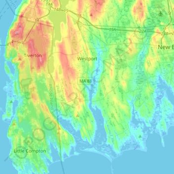
Name: Westport topographic map, elevation, terrain.
Location: Westport, Bristol County, Massachusetts, United States (41.48186 -71.13835 41.69280 -71.02231)
Average elevation: 23 m
Minimum elevation: -22 m
Maximum elevation: 92 m
Make a donation
Other topographic maps
Click on a map to view its topography, its elevation and its terrain.
Make a donation
Make a donation
Make a donation
Make a donation
Source Is Shapefile From Town
United States > Massachusetts > Bristol County > Mansfield > Robinsonville
Average elevation: 50 m
Make a donation
North Attleborough
United States > Massachusetts > Bristol County > North Attleborough > North Attleborough
Average elevation: 65 m
Make a donation
Kirby Corner
United States > Massachusetts > Bristol County > Westport > Kirby Corner
Average elevation: 33 m
Fall River Station
United States > Massachusetts > Bristol County > Fall River > Fall River Station
Average elevation: 28 m
Make a donation
Brownell Corner
United States > Massachusetts > Bristol County > Westport > Brownell Corner
Average elevation: 49 m
Make a donation