
Thank you for supporting this site ❤️
Make a donation
Make a donation
Saint-Imier topographic map
Click on the map to display elevation.
Thank you for supporting this site ❤️
Make a donation
Make a donation
About this map
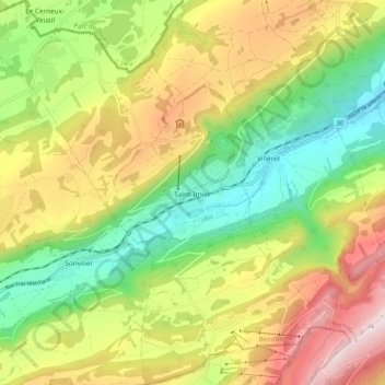
Name: Saint-Imier topographic map, elevation, terrain.
Average elevation: 1,083 m
Minimum elevation: 716 m
Maximum elevation: 1,564 m
Thank you for supporting this site ❤️
Make a donation
Make a donation
Other topographic maps
Click on a map to view its topography, its elevation and its terrain.
Chaindon
Switzerland > Bern > Bernese Jura administrative district > Reconvilier
Average elevation: 845 m