
Thank you for supporting this site ❤️
Make a donation
Make a donation
Monghidoro topographic map
Click on the map to display elevation.
Thank you for supporting this site ❤️
Make a donation
Make a donation
Monghidoro
The territory surrounding the municipality is, for the largest part, mountainous with elevations ranging between a minimum of 400 metres (1,300 ft) above sea level to the north-east to a maximum of 1,290 metres (4,230 ft) on its southern flank.
Thank you for supporting this site ❤️
Make a donation
Make a donation
About this map
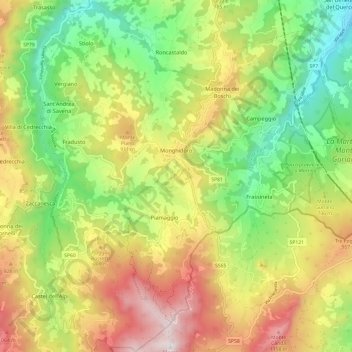
Name: Monghidoro topographic map, elevation, terrain.
Average elevation: 732 m
Minimum elevation: 315 m
Maximum elevation: 1,271 m
Thank you for supporting this site ❤️
Make a donation
Make a donation
Other topographic maps
Click on a map to view its topography, its elevation and its terrain.
Thank you for supporting this site ❤️
Make a donation
Make a donation
Possessione Piccola
Italy > Emilia-Romagna > Bologna > San Giovanni in Persiceto
Average elevation: 25 m
Thank you for supporting this site ❤️
Make a donation
Make a donation
Thank you for supporting this site ❤️
Make a donation
Make a donation
Thank you for supporting this site ❤️
Make a donation
Make a donation
San Vitale Grande
Italy > Emilia-Romagna > Bologna > Calderara di Reno > Lippo
Average elevation: 33 m
Thank you for supporting this site ❤️
Make a donation
Make a donation
Thank you for supporting this site ❤️
Make a donation
Make a donation
Thank you for supporting this site ❤️
Make a donation
Make a donation
Thank you for supporting this site ❤️
Make a donation
Make a donation