
Thank you for supporting this site ❤️
Make a donation
Make a donation
The Plains topographic map
Click on the map to display elevation.
Thank you for supporting this site ❤️
Make a donation
Make a donation
About this map
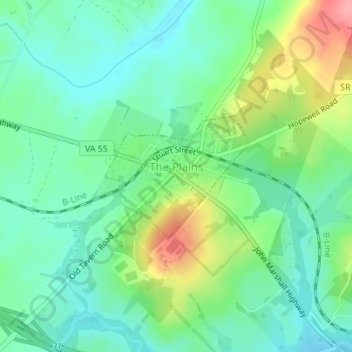
Name: The Plains topographic map, elevation, terrain.
Location: The Plains, Fauquier County, Virginia, United States (38.85703 -77.78110 38.86640 -77.76691)
Average elevation: 180 m
Minimum elevation: 147 m
Maximum elevation: 253 m
Thank you for supporting this site ❤️
Make a donation
Make a donation
Other topographic maps
Click on a map to view its topography, its elevation and its terrain.
Thank you for supporting this site ❤️
Make a donation
Make a donation
Thank you for supporting this site ❤️
Make a donation
Make a donation