
Thank you for supporting this site ❤️
Make a donation
Make a donation
Hagåtña topographic map
Click on the map to display elevation.
Thank you for supporting this site ❤️
Make a donation
Make a donation
About this map
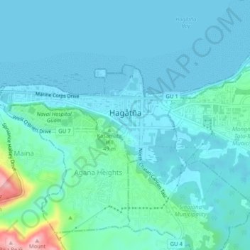
Name: Hagåtña topographic map, elevation, terrain.
Location: Hagåtña, Guam, United States (13.46302 144.72507 13.48535 144.76501)
Average elevation: 25 m
Minimum elevation: 0 m
Maximum elevation: 209 m
Thank you for supporting this site ❤️
Make a donation
Make a donation
Other topographic maps
Click on a map to view its topography, its elevation and its terrain.
Apaca Point, War in the Pacific National Historical Park
United States > Guam > Sånta Rita-Sumai Municipality
Average elevation: 9 m
Mount Lamlam
United States > Guam > Hågat Municipality
Rising to 406 meters (1,332 ft) above sea level, the distance from the peak to the bottom of the nearby Mariana Trench is said to be the greatest change in elevation on Earth over such a short distance.
Average elevation: 223 m
Fonte Plateau Unit War In the Pacific National Historical Park
United States > Guam > Maina
Average elevation: 120 m
Thank you for supporting this site ❤️
Make a donation
Make a donation