
Make a donation
Champigny topographic map
Click on the map to display elevation.
Make a donation
Champigny
Plusieurs études ont été menées afin de caractériser les types climatiques auxquels est exposé le territoire national. Les zonages obtenus diffèrent selon les méthodes utilisées, la nature et le nombre des paramètres pris en compte, le maillage territorial des données et la période de référence. En 2010, le climat de la commune était ainsi de type climat océanique dégradé des plaines du Centre et du Nord, selon une étude du Centre national de la recherche scientifique (CNRS) s'appuyant sur une méthode combinant données climatiques et facteurs de milieu (topographie, occupation des sols, etc.) et des données couvrant la période 1971-2000. En 2020, le climat prédominant est classé Cfb, selon la classification de Köppen-Geiger, pour la période 1988-2017, à savoir un climat tempéré à été frais sans saison sèche. Par ailleurs Météo-France publie en 2020 une nouvelle typologie des climats de la France métropolitaine dans laquelle la commune est exposée à un climat océanique altéré et est dans la région climatique Nord-est du bassin Parisien, caractérisée par un ensoleillement médiocre, une pluviométrie moyenne régulièrement répartie au cours de l’année et un hiver froid (3 °C). Elle est en outre dans la zone H1b au titre de la réglementation environnementale 2020 des constructions neuves.
Make a donation
About this map
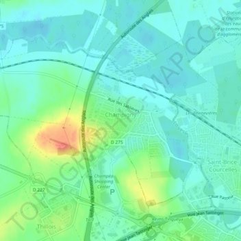
Name: Champigny topographic map, elevation, terrain.
Average elevation: 81 m
Minimum elevation: 68 m
Maximum elevation: 118 m
Make a donation
Other topographic maps
Click on a map to view its topography, its elevation and its terrain.
Réserve biologique dirigée de Faux de Verzy
France > Grand Est > Marne > Verzy
Average elevation: 248 m
Make a donation
Make a donation
Make a donation
Montigny-sous-Chatillon
France > Grand Est > Marne > Châtillon-sur-Marne > Montigny-sous-Chatillon
Average elevation: 136 m
Make a donation
Make a donation
Make a donation
Mareuil-sur-Ay
France > Grand Est > Marne > Aÿ-Champagne
La partie la plus ancienne du village, à l'est, est construite à flanc de coteaux et est dominée par la statue Notre-Dame du Gruguet, à environ 130 mètres d'altitude. Les quartiers de l'ouest sont plus récents. Le quartier des Carelles, à l'ouest, est contigu à la ville d'Ay.
Average elevation: 91 m
Make a donation
Make a donation
Bisseuil
France > Grand Est > Marne > Aÿ-Champagne
Bisseuil se situe au pied de la montagne de Reims, dont les coteaux sont plantés de 125 hectares de vignes appartenant au vignoble de la vallée de la Marne. Le massif recouvre tout le nord de la commune. La vallée de la Crayère s'y avance, perpendiculairement au canal. Le village est dominé à l'est par…
Average elevation: 94 m
Make a donation
Make a donation
Make a donation
Make a donation
Make a donation
Le Mesnil-lès-Hurlus (Village Détruit)
France > Grand Est > Marne > Minaucourt-le-Mesnil-lès-Hurlus
Average elevation: 173 m
Make a donation
Make a donation
Make a donation
Make a donation
Make a donation
Blaise sous Hauteville
France > Grand Est > Marne > Sainte-Marie-du-Lac-Nuisement
Average elevation: 130 m
Make a donation
Make a donation
Make a donation
Make a donation
Make a donation