
Thank you for supporting this site ❤️
Make a donation
Make a donation
White Island topographic map
Click on the map to display elevation.
Thank you for supporting this site ❤️
Make a donation
Make a donation
About this map
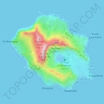
Name: White Island topographic map, elevation, terrain.
Location: White Island, Bay of Plenty, New Zealand (-37.53040 177.16694 -37.50976 177.19578)
Average elevation: 38 m
Minimum elevation: -4 m
Maximum elevation: 310 m
Thank you for supporting this site ❤️
Make a donation
Make a donation
Other topographic maps
Click on a map to view its topography, its elevation and its terrain.