
Thank you for supporting this site ❤️
Make a donation
Make a donation
Sanaag topographic map
Click on the map to display elevation.
Thank you for supporting this site ❤️
Make a donation
Make a donation
About this map
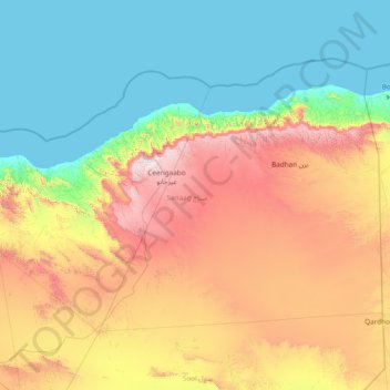
Name: Sanaag topographic map, elevation, terrain.
Location: Sanaag, Somalia (9.42000 46.01003 11.52611 49.06000)
Average elevation: 621 m
Minimum elevation: 0 m
Maximum elevation: 2,392 m
Thank you for supporting this site ❤️
Make a donation
Make a donation
Other topographic maps
Click on a map to view its topography, its elevation and its terrain.
Mogadishu
Somalia > Banaadir > Hamar Weyne District
Mogadishu is located in or near the tropical thorn woodland biome of the Holdridge global bioclimatic scheme. The mean temperature in the city year-round is 27 °C (81 °F), with an average maximum of 30 °C (86 °F) and an average minimum of 24 °C (75 °F). Mean temperature readings per month vary by 3 °C…
Average elevation: 43 m
Thank you for supporting this site ❤️
Make a donation
Make a donation