
Thank you for supporting this site ❤️
Make a donation
Make a donation
Villeneuve-Loubet topographic map
Click on the map to display elevation.
Thank you for supporting this site ❤️
Make a donation
Make a donation
About this map
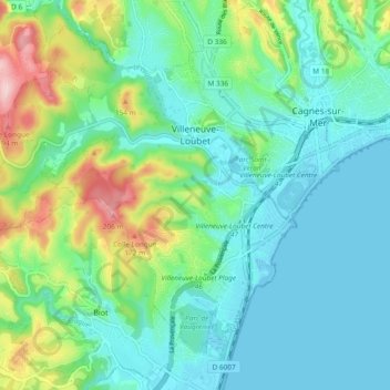
Name: Villeneuve-Loubet topographic map, elevation, terrain.
Average elevation: 55 m
Minimum elevation: -1 m
Maximum elevation: 220 m
Thank you for supporting this site ❤️
Make a donation
Make a donation
Other topographic maps
Click on a map to view its topography, its elevation and its terrain.
Cime de la Bonette
France > Provence-Alpes-Côte d'Azur > Maritime Alps > Saint-Dalmas-le-Selvage
Average elevation: 2,512 m