
Thank you for supporting this site ❤️
Make a donation
Make a donation
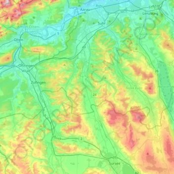
Suhre topographic map
Click on the map to display elevation.
Thank you for supporting this site ❤️
Make a donation
Make a donation
Suhre
The river Suhre is a 34 kilometer long tributary of the river Aare in the Swiss cantons of Lucerne and Aargau. The river rises in Sempachersee (or Lake Sempach) at an elevation of 504 meters above sea level, and joins the Aare east of the town Aarau at an elevation of 362 meters. The most important side valley is the Ruedertal, which joins the Suhretal (or Suhre Valley) at Schöftland.
Thank you for supporting this site ❤️
Make a donation
Make a donation
About this map
Name: Suhre topographic map, elevation, terrain.
Location: Suhre, Bezirk Zofingen, Aargau, Switzerland (47.15715 8.04449 47.40615 8.12201)
Average elevation: 543 m
Minimum elevation: 360 m
Maximum elevation: 992 m
Thank you for supporting this site ❤️
Make a donation
Make a donation