
Thank you for supporting this site ❤️
Make a donation
Make a donation
Kurdistan Province topographic map
Click on the map to display elevation.
Thank you for supporting this site ❤️
Make a donation
Make a donation
About this map
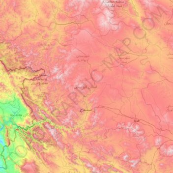
Name: Kurdistan Province topographic map, elevation, terrain.
Location: Kurdistan Province, Iran (34.73657 45.55765 36.45945 48.29018)
Average elevation: 1,754 m
Minimum elevation: 374 m
Maximum elevation: 3,287 m
Thank you for supporting this site ❤️
Make a donation
Make a donation
Other topographic maps
Click on a map to view its topography, its elevation and its terrain.
Padig
Iran > Sistan and Baluchestan Province > Sarbaz County > دهستان سرکور
Average elevation: 1,305 m
Thank you for supporting this site ❤️
Make a donation
Make a donation
Baba Jan, East Azerbaijan
Iran > East Azerbaijan Province > Ahar County > دهستان قشلاق
Average elevation: 1,752 m
Thank you for supporting this site ❤️
Make a donation
Make a donation
Lorega
Iran > Chaharmahal and Bakhtiyari Province > Kuhrang County > دهستان میان کوه موگوئی
Average elevation: 3,364 m