
Albacete topographic map
Interactive map
Click on the map to display elevation.
About this map
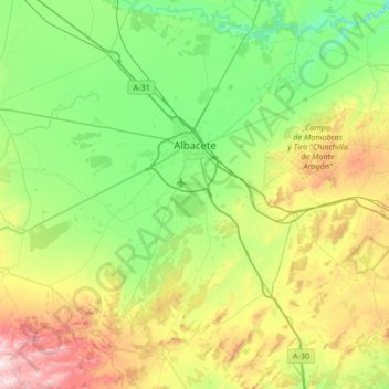
Name: Albacete topographic map, elevation, terrain.
Location: Albacete, Castile-La Mancha, Spain (38.67218 -2.18039 39.18626 -1.62279)
Average elevation: 786 m
Minimum elevation: 560 m
Maximum elevation: 1,341 m
Albacete is located in the South-East of the Iberian Peninsula, in the plains of La Mancha (part of the Inner Plateau), at an elevation of about 686 metres (2,251 feet).