
Maura topographic map
Interactive map
Click on the map to display elevation.
About this map
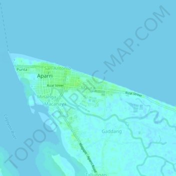
Name: Maura topographic map, elevation, terrain.
Location: Maura, Aparri, Cagayan, Cagayan Valley, 3515, Philippines (18.33454 121.62782 18.37454 121.66782)
Average elevation: 1 m
Minimum elevation: -2 m
Maximum elevation: 9 m
Other topographic maps
Click on a map to view its topography, its elevation and its terrain.
Paddaya
Philippines > Cagayan > Aparri
Paddaya, Aparri, Cagayan, Cagayan Valley, Philippines
Average elevation: 1 m