
Make a donation
Maui topographic map
Click on the map to display elevation.
Make a donation
Maui
The climate is characterized by a two-season year, tropical and uniform temperatures at any given elevation, geographic differences in rainfall, high relative humidity, extensive cloud formations (except on the leeward coasts and at the highest elevations), and dominant trade wind flow (especially at lower elevations).
Make a donation
About this map
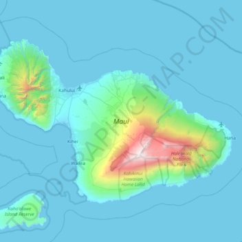
Name: Maui topographic map, elevation, terrain.
Location: Maui, Maui County, Hawaii, United States (20.57443 -156.69726 21.03156 -155.97909)
Average elevation: 232 m
Minimum elevation: -4 m
Maximum elevation: 3,044 m
Make a donation
Other topographic maps
Click on a map to view its topography, its elevation and its terrain.
Kula
United States > Hawaii > Maui County
Kula is a district and census-designated place (CDP) of Maui, Hawaii, that stretches across the "up-country", the western-facing slopes of Haleakalā, from Makawao to Kanaio. Most of the residential areas lie between about 500 to 1,100 m (1,600 to 3,600 ft) in elevation. The district has traditionally been…
Average elevation: 740 m
Make a donation
Make a donation
Haleakalā Observatories
United States > Hawaii > Maui County
The Haleakalā Observatory, also known as the Haleakalā High Altitude Observatory Site, is Hawaii's first astronomical research observatory. It is located on the island of Maui and is owned by the Institute for Astronomy of the University of Hawaiʻi, which operates some of the facilities on the site and…
Average elevation: 2,811 m
Make a donation
Kula
United States > Hawaii > Maui County
Kula is a census-designated place (CDP) of Maui, Hawaii. It stretches across Upcountry Maui, the western-facing slopes of Haleakalā. Most residential areas lie between about 500 to 1,100 m (1,600 to 3,600 ft) in elevation. The district is distinct from the generally hotter and busier coastal areas. The…
Average elevation: 740 m
Make a donation
Molokini Shoal Marine Life Conservation District
United States > Hawaii > Maui County
Average elevation: 0 m
Make a donation
Make a donation