
Thank you for supporting this site ❤️
Make a donation
Make a donation
Ljubljana topographic map
Click on the map to display elevation.
Thank you for supporting this site ❤️
Make a donation
Make a donation
About this map
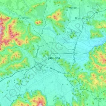
Name: Ljubljana topographic map, elevation, terrain.
Location: Ljubljana, Upravna Enota Ljubljana, Slovenia (45.97406 14.40862 46.14600 14.75533)
Average elevation: 355 m
Minimum elevation: 257 m
Maximum elevation: 886 m
Thank you for supporting this site ❤️
Make a donation
Make a donation
Other topographic maps
Click on a map to view its topography, its elevation and its terrain.
Thank you for supporting this site ❤️
Make a donation
Make a donation