
Thank you for supporting this site ❤️
Make a donation
Make a donation
Longares topographic map
Click on the map to display elevation.
Thank you for supporting this site ❤️
Make a donation
Make a donation
About this map
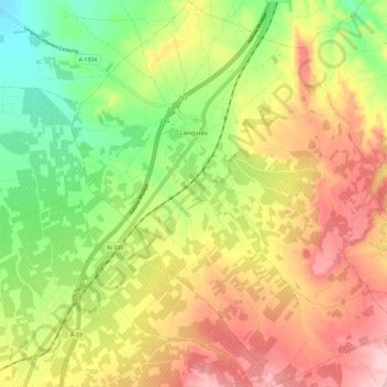
Name: Longares topographic map, elevation, terrain.
Location: Longares, Campo de Cariñena, Zaragoza, Aragon, Spain (41.34508 -1.20508 41.43292 -1.10748)
Average elevation: 567 m
Minimum elevation: 462 m
Maximum elevation: 678 m
Thank you for supporting this site ❤️
Make a donation
Make a donation
Other topographic maps
Click on a map to view its topography, its elevation and its terrain.
"El Cerro la Silla" (Cima oeste)
Spain > Aragon > Campo de Cariñena > Cosuenda
Average elevation: 954 m
"El Cerro la Silla" (Cima oeste)
Spain > Aragon > Campo de Cariñena > Cosuenda
Average elevation: 954 m