
Make a donation
Yamagata Prefecture topographic map
Click on the map to display elevation.
Make a donation
Yamagata Prefecture
The climate of Yamagata Prefecture is characterized by long, hot, and humid summers and long, snowy winters. Both spring and autumn are short, the former often cold, the latter often warm, but both quite dry and sunny. Yamagata Prefecture, along with northern parts of Miyagi and Iwate are the transition areas from humid subtropical climate (Koppen Cfa/Cwa) to humid continental within the Japan mainland. Winter temperatures rarely fall below −10 °C (14 °F) in populated areas; they frequently rise above 30 °C (86 °F) in July and August. Precipitation falls all year round and the remnants of one or perhaps two typhoons usually pass through between August and October. The winters see heavy snowfall especially at higher elevations, though the Japan Sea coast (Sakata) is milder and has more rain. Snowfall for Shinjō is typical of populated mountainous areas, snowfall for Yamagata City typical of the valleys. The central mountains around Gassan may see as much as 3,000 centimetres (98.43 ft) of snow in a season with depths up to 8 metres (26 ft) at higher elevations.
Make a donation
About this map
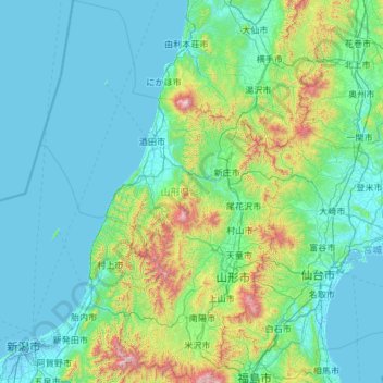
Name: Yamagata Prefecture topographic map, elevation, terrain.
Location: Yamagata Prefecture, Japan (37.73383 139.13822 39.59287 140.64647)
Average elevation: 222 m
Minimum elevation: -3 m
Maximum elevation: 2,198 m
Make a donation
Other topographic maps
Click on a map to view its topography, its elevation and its terrain.