Swynnerton topographic map
Interactive map
Click on the map to display elevation.
About this map
![Swynnerton topographic map, elevation, terrain](/pub/maps/relation/dntf/whh5zs/thumbnail.jpg)
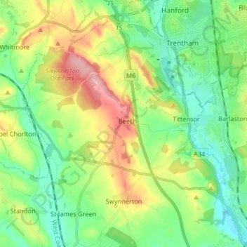
Name: Swynnerton topographic map, elevation, terrain.
Location: Swynnerton, Stafford, Staffordshire, England, United Kingdom (52.90122 -2.27802 52.98056 -2.18032)
Average elevation: 133 m
Minimum elevation: 84 m
Maximum elevation: 229 m
Other topographic maps
Click on a map to view its topography, its elevation and its terrain.
![Ranton topographic map, elevation, terrain](/pub/maps/relation/wv18/9tvc18/icon.jpg)
Ranton
United Kingdom > England > Staffordshire > Stafford
Ranton, Stafford, Staffordshire, England, United Kingdom
Average elevation: 103 m
![Barlaston topographic map, elevation, terrain](/pub/maps/relation/15m2/xppzf3/icon.jpg)
Barlaston
United Kingdom > England > Staffordshire > Stafford
Barlaston, Stafford, Staffordshire, England, United Kingdom
Average elevation: 132 m
![Bradley topographic map, elevation, terrain](/pub/maps/node/xzs/lr3mb7zs/icon.jpg)
Bradley
United Kingdom > England > Staffordshire > Stafford
Bradley, Stafford, Staffordshire, England, ST18 9DR, United Kingdom
Average elevation: 110 m
![Moreton topographic map, elevation, terrain](/pub/maps/node/drgp/96pkb5f3/icon.jpg)
Moreton
United Kingdom > England > Staffordshire > Stafford
Moreton, Stafford, Staffordshire, England, TF10 9DS, United Kingdom
Average elevation: 95 m
![Outwoods topographic map, elevation, terrain](/pub/maps/node/m14/31ddt3z4/icon.jpg)
Outwoods
United Kingdom > England > Staffordshire > Stafford
Outwoods, Stafford, Staffordshire, England, TF10 9EA, United Kingdom
Average elevation: 88 m
![Aston-by-Stone topographic map, elevation, terrain](/pub/maps/node/4hcz/l79fpr4s/icon.jpg)
Aston-by-Stone
United Kingdom > England > Staffordshire > Stafford
Aston-by-Stone, Stafford, Staffordshire, England, ST15 0BN, United Kingdom
Average elevation: 108 m
![Standon Mill topographic map, elevation, terrain](/pub/maps/node/kmz4/knnkqj3l/icon.jpg)
Standon Mill
United Kingdom > England > Staffordshire > Stafford
Standon Mill, Stafford, Staffordshire, England, ST21 6RP, United Kingdom
Average elevation: 119 m
![Marston topographic map, elevation, terrain](/pub/maps/node/9gf3/6tz5lkl/icon.jpg)
Marston
United Kingdom > England > Staffordshire > Stafford
Marston, Stafford, Staffordshire, England, ST18 9ST, United Kingdom
Average elevation: 105 m
![Drointon topographic map, elevation, terrain](/pub/maps/node/bwzs/t7pxbwdn/icon.jpg)
Drointon
United Kingdom > England > Staffordshire > Stafford > Stowe-by-Chartley
Drointon, Stowe-by-Chartley, Stafford, Staffordshire, England, ST18 0LX, United Kingdom
Average elevation: 110 m
![Beech topographic map, elevation, terrain](/pub/maps/node/xj4s/pn86xzdn/icon.jpg)
Beech
United Kingdom > England > Staffordshire > Stafford > Beech
Beech, Stafford, Staffordshire, England, ST4 8SH, United Kingdom
Average elevation: 153 m
![Gnosall topographic map, elevation, terrain](/pub/maps/relation/gbf3/xpn9f3/icon.jpg)
Gnosall
United Kingdom > England > Staffordshire > Stafford
Gnosall, Stafford, Staffordshire, England, United Kingdom
Average elevation: 105 m
![Hixon topographic map, elevation, terrain](/pub/maps/relation/xh18/d18jgp/icon.jpg)
Hixon
United Kingdom > England > Staffordshire > Stafford > Hixon
Hixon, Stafford, Staffordshire, England, United Kingdom
Average elevation: 93 m
![Yarnfield topographic map, elevation, terrain](/pub/maps/node/3814/hhzxltp/icon.jpg)
Yarnfield
United Kingdom > England > Staffordshire > Stafford
Yarnfield, Stafford, Staffordshire, England, ST15 0NA, United Kingdom
Average elevation: 108 m
![Weston topographic map, elevation, terrain](/pub/maps/relation/wmf3/gm7v3l/icon.jpg)
Weston
United Kingdom > England > Staffordshire > Stafford > Weston
Weston, Stafford, Staffordshire, West Midlands, England, United Kingdom
Average elevation: 93 m
![Brocton topographic map, elevation, terrain](/pub/maps/relation/bfzs/whn8zs/icon.jpg)
Brocton
United Kingdom > England > Staffordshire > Stafford > Brocton
Brocton, Stafford, Staffordshire, West Midlands, England, United Kingdom
Average elevation: 142 m
![Knightley topographic map, elevation, terrain](/pub/maps/node/7l1h/js1hj3zs/icon.jpg)
Knightley
United Kingdom > England > Staffordshire > Stafford > Gnosall > Knightley
Knightley, Gnosall, Stafford, Staffordshire, West Midlands, England, ST20 0JP, United Kingdom
Average elevation: 127 m
![Hilderstone topographic map, elevation, terrain](/pub/maps/relation/dbmt/d186tp/icon.jpg)
Hilderstone
United Kingdom > England > Staffordshire > Stafford > Hilderstone
Hilderstone, Stafford, Staffordshire, West Midlands, England, United Kingdom
Average elevation: 188 m
![Milford topographic map, elevation, terrain](/pub/maps/node/8nh/vw2b37tj/icon.jpg)
Milford
United Kingdom > England > Staffordshire > Stafford > Milford
Milford, Berkswich, Milford, Stafford, Staffordshire, England, ST17 0UL, United Kingdom
Average elevation: 103 m
![Moddershall topographic map, elevation, terrain](/pub/maps/node/xfzs/lnzs5lzs/icon.jpg)
Moddershall
United Kingdom > England > Staffordshire > Stafford
Moddershall, Stafford, Staffordshire, England, ST15 8TG, United Kingdom
Average elevation: 185 m
![Fradswell topographic map, elevation, terrain](/pub/maps/relation/3cm2/xhd1f3/icon.jpg)
Fradswell
United Kingdom > England > Staffordshire > Stafford > Fradswell
Fradswell, Stafford, Staffordshire, West Midlands, England, United Kingdom
Average elevation: 143 m
![Ingestre topographic map, elevation, terrain](/pub/maps/relation/j7tf/bmpltf/icon.jpg)
Ingestre
United Kingdom > England > Staffordshire > Stafford
Ingestre, Stafford, Staffordshire, England, United Kingdom
Average elevation: 92 m
![Woodseaves topographic map, elevation, terrain](/pub/maps/node/xg57/9413qt6/icon.jpg)
Woodseaves
United Kingdom > England > Staffordshire > Stafford
Woodseaves, Stafford, Staffordshire, England, ST20 0LR, United Kingdom
Average elevation: 122 m
![High Offley topographic map, elevation, terrain](/pub/maps/relation/4k1h/7vvsz4/icon.jpg)
High Offley
United Kingdom > England > Staffordshire > Stafford
High Offley, Stafford, Staffordshire, England, United Kingdom
Average elevation: 111 m
![Tittensor topographic map, elevation, terrain](/pub/maps/node/h651/5pgz2tnx/icon.jpg)
Tittensor
United Kingdom > England > Staffordshire > Stafford
Tittensor, Stafford, Staffordshire, England, ST12 9JN, United Kingdom
Average elevation: 127 m
![Stallington topographic map, elevation, terrain](/pub/maps/node/74f3/v1lf8nh/icon.jpg)
Stallington
United Kingdom > England > Staffordshire > Stafford
Stallington, Stafford, Staffordshire, England, ST11 9QF, United Kingdom
Average elevation: 202 m
![Seighford topographic map, elevation, terrain](/pub/maps/node/t43q/mzx7pgp/icon.jpg)
Seighford
United Kingdom > England > Staffordshire > Stafford
Seighford, Stafford, Staffordshire, England, ST18 9PJ, United Kingdom
Average elevation: 89 m
![Cotes Heath topographic map, elevation, terrain](/pub/maps/node/ssz4/w34kmr18/icon.jpg)
Cotes Heath
United Kingdom > England > Staffordshire > Stafford > St James Green > Cranberry
Cotes Heath, Cranberry, Standon, St James Green, Stafford, Staffordshire, England, ST21 6RT, United Kingdom
Average elevation: 119 m
![Haughton topographic map, elevation, terrain](/pub/maps/relation/m6cz/hgxscz/icon.jpg)
Haughton
United Kingdom > England > Staffordshire > Stafford
Haughton, Stafford, Staffordshire, England, United Kingdom
Average elevation: 105 m
![Hanchurch topographic map, elevation, terrain](/pub/maps/node/f2f3/hpntpdgp/icon.jpg)
Hanchurch
United Kingdom > England > Staffordshire > Stafford > Swynnerton
Hanchurch, Swynnerton, Stafford, Staffordshire, England, ST4 8RY, United Kingdom
Average elevation: 146 m
![Bishop's Offley topographic map, elevation, terrain](/pub/maps/node/fnh/8cjt3fz4/icon.jpg)
Bishop's Offley
United Kingdom > England > Staffordshire > Stafford > Adbaston
Bishop's Offley, Adbaston, Stafford, Staffordshire, England, ST21 6ET, United Kingdom
Average elevation: 121 m
![Great Haywood topographic map, elevation, terrain](/pub/maps/node/s9mt/lpg3xzs/icon.jpg)
Great Haywood
United Kingdom > England > Staffordshire > Stafford
Great Haywood, Stafford, Staffordshire, England, ST18 0FY, United Kingdom
Average elevation: 89 m
![Church Eaton topographic map, elevation, terrain](/pub/maps/node/hb3/395ssv14/icon.jpg)
Church Eaton
United Kingdom > England > Staffordshire > Stafford
Church Eaton, Stafford, Staffordshire, England, ST20 0AL, United Kingdom
Average elevation: 101 m
![Little Haywood topographic map, elevation, terrain](/pub/maps/relation/wss8/9t14s8/icon.jpg)
Little Haywood
United Kingdom > England > Staffordshire > Stafford > Little Haywood
Colwich, Stafford, Little Haywood, Staffordshire, England, United Kingdom
Average elevation: 104 m