
Thank you for supporting this site ❤️
Make a donation
Make a donation
Jiménez topographic map
Click on the map to display elevation.
Thank you for supporting this site ❤️
Make a donation
Make a donation
About this map
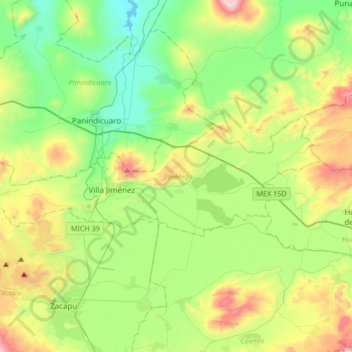
Name: Jiménez topographic map, elevation, terrain.
Location: Jiménez, Michoacán, Mexico (19.88050 -101.88202 19.98812 -101.54781)
Average elevation: 2,021 m
Minimum elevation: 1,706 m
Maximum elevation: 2,710 m
Thank you for supporting this site ❤️
Make a donation
Make a donation
Other topographic maps
Click on a map to view its topography, its elevation and its terrain.