
Thank you for supporting this site ❤️
Make a donation
Make a donation
Kaduna State topographic map
Click on the map to display elevation.
Thank you for supporting this site ❤️
Make a donation
Make a donation
About this map
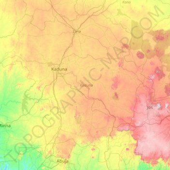
Name: Kaduna State topographic map, elevation, terrain.
Location: Kaduna State, Nigeria (9.00064 6.08653 11.52377 8.82352)
Average elevation: 634 m
Minimum elevation: 122 m
Maximum elevation: 1,671 m
Thank you for supporting this site ❤️
Make a donation
Make a donation
Other topographic maps
Click on a map to view its topography, its elevation and its terrain.
Ibadan
Nigeria > Oyo State > Ibadan South West
Ibadan, coined from the phrase "Eba Odan", which literally means 'by the edge of the meadow', came into existence in 1829, during a period of turmoil that characterized Yorubaland at the time. It was in this period that many old Yoruba cities such as old Oyo (Oyo ile), Ijaye and Owu disappeared, and newer ones…
Average elevation: 191 m
Thank you for supporting this site ❤️
Make a donation
Make a donation