
Make a donation
Maitencillo topographic map
Click on the map to display elevation.
Make a donation
About this map
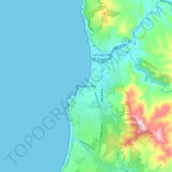
Name: Maitencillo topographic map, elevation, terrain.
Average elevation: 74 m
Minimum elevation: -1 m
Maximum elevation: 443 m
Make a donation
Other topographic maps
Click on a map to view its topography, its elevation and its terrain.
Isla Alejandro Selkirk
Chile > Valparaiso Region > Provincia de Valparaíso > Juan Fernández
Alejandro Selkirk has a subtropical climate, moderated by the cold Humboldt Current and the southeast trade winds. Temperatures range from 3 °C (37 °F) to 34 °C (93 °F), with an annual mean of 15.4 °C (59.7 °F). Higher elevations are generally cooler. Average annual precipitation is 1,081 mm (42.6 in),…
Average elevation: 265 m
Make a donation
Make a donation
Isla San Félix
Chile > Valparaiso Region > Provincia de Valparaíso > Valparaíso > Isla San Félix
Average elevation: 10 m
Playa Laguna Verde
Chile > Valparaiso Region > Provincia de Valparaíso > Valparaíso > Laguna Verde
Average elevation: 70 m
Make a donation